
doc
Well-known member
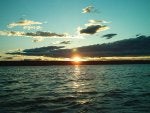
Can You Read A Lake?
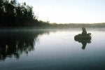
Every year more people are heading out to local trout lakes and ponds in search of cooperative trout. Float tubes and pontoon boats are now quite common and they no longer get as many head turns and pointed fingers they once did. The reason for the growing number of fly anglers is simple. Convenience. Most cities and towns throughout North America can find trout lakes and ponds fairly close to home. These stillwater fisheries may be privately stocked pay and play lakes or state/provincially stocked waters. For a good number of fly anglers, these waters are closer than their nearest streams and the convenience of these fisheries is not being over looked.
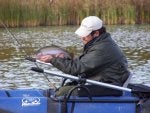
Although newly stocked trout (stockers) are fairly easy to catch, many anglers report that the larger trout in these stillwater fisheries are hard to find and not as cooperative as they should be. Or maybe it's that the average fly angler doesn't know where to look.
Fishing a lake or a stream can be difficult and will create complications, especially for novices. Leader shy trout will require you to have just the right size tippet when casting a dry fly. Closely matching the hatch with the right pattern and size of fly can be an issue for fussy trout. And there may be no hatch coming off at all - at least not one that's obvious - leaving you with the decision of what nymphs (wet flies) to use. How well you present your fly to selective trout and where to cast your fly can also have a huge impact on your success. There can be many problems an angler must work into the trout equation but with practice comes experience and secrets are soon revealed. To achieve positive results, reading the water on a lake or stream is a secret best discovered sooner than later and knowing where trout are holding or at least where they should be holding really is half the battle. Lakes and ponds however, are considerably different than streams and 'reading' still water fisheries can be intimidating for new fly anglers and even some seasoned stream veterans.

So how do you read a lake where there are no obvious fast riffles, deep runs or fish-holding boulders? There may be no obvious structure like in a stream, but there is structure even if it is in a different form. And like fishing streams, with practice, lake fly anglers can learn where the high probability and prime holding areas are in the stillwater's they fish.
A prime lie in a stream would be considered anywhere that the trout can find food, shelter from predators and suitable levels of oxygen (comfort zone). These are the three basic necessities of trout and the same needs must be met in a lake or pond. One primary difference between streams and lakes is that trout in streams tend to hold in one place waiting for food to come to them. However, in lakes, trout cruise around looking for food in specific, prime areas, and these are the places you'll want to concentrate on. stillwater trout search for most of their food at the drop-offs and shoal areas. But what are drop-offs, what are shoals and how does a lake fly angler find them?
A drop-off is the part of the lake bottom that, well, like the name implies, drops off. From the shoreline to the drop-off, you will find a shallow area known as the shoal. Usually somewhat weedy, the shoal is home to many insects like Dragonfly nymphs and Scuds as well as aquatic life including minnows and leeches. The trout will swim up from the drop-off, feed on the shoal and drop back down again. According to the amount of light, how warm the water is and how much weed cover a trout has on the shoal will usually dictate when and how much time a trout will spend in the shoal area. The shoal is quite shallow making it to easy for predators, like Osprey, to see trout. And trout being as cautious as they are will not stay on the shoal for very long. During the day, trout will usually make quick shopping trips onto the shoal them drop back down the drop-off. The water in the shoal area can also be very warm and uncomfortable for the trout, which will also make trips to the shoal quick. It's in the evening, throughout the night and early mornings as well as cool overcast days that we'll see trout spending more time in these shoal areas feeding. Autumn will also see trout spending more time on the shoals fattening up for winter. And early spring after ice-out will see trout in these shallow areas, as the water in the shoal area will warm up faster increasing insect activity quicker than in the deeper, colder sections of the lake. Sometimes when there is a lot of insect activity like the late spring Damselfly migration, the trout will throw caution to the wind and hang on the shoal feeding for long periods of time even on bright, sunny, warm days.
The shoal and drop-off transition is an important structure for fish-and for anglers. Aquatic insects and small forage fish will frequently move near and even beyond or down the drop-off area making easy meals for searching trout. This is what I like to refer to as the 'Strike Zone' and it's where you'll get most of your strikes and hook-ups on your flies. Anglers fishing these structures with sub-surface patterns are best to experiment with medium to fast sink lines or sink tips and floating lines with added weight.

Weed beds are another important structure for fish and anglers. Like the weed cover we see in the shoal areas, mid-lake weed beds also hold insects and aquatic life forms and give good cover to cruising trout. Anglers will often find large numbers of trout at anytime of day searching for food here even when the water is quite warm. You can find weed beds in many different areas of a stillwater fishery, many times right in the middle of the lake. Mid-lake weed beds usually grow on humps where the water is relatively shallow, quite often giving us smaller drop-offs to fish. Some weed beds can be seen from the surface and some are sub surface. You can have many days fishing weed beds with unbelievable catch rates by just concentrating on this structure alone. Leech, Damselfly nymph and many dry fly patterns work incredibly well when casting around the edges, directly into or over top of these weed beds. A slow or medium sink line as well as a floating line with or without added weight will all work well here according to what bugs the trout are keyed on to.
Another structure that is highly overlooked when stillwater fishing is along the shoreline. A lot of aquatic life forms are found very close to the shoreline in very shallow water including Water boatmen, Scuds and Leeches. Although you will find these life forms throughout the lake, concentrations will be much higher close to the shorelines. In low light conditions trout will be less cautious and feed in these areas due to the large number of bugs here. It's not uncommon to arrive at a body of water at first light and see trout swirling only a few feet away from the shore. On windy days, it's in the angler's best interest to head over to the shoreline being pounded by the wind driven waves. These waves will not only give the trout a choppy cover from predators but will also stir up insects from the bottom and force then into these shorelines. A floating line or a slow sinking line will produce well along shorelines while keeping your fly from consistently picking up weeds and debris.
The deeper sections of a lake will also see trout. On hot summer days you'll find trout moving deeper where conditions are cooler and more oxygen rich, feeding on chironomid larva, chironomid pupa, Dragonfly nymphs and other aquatic life forms but oxygen levels usually dictate how deep fish will hold. A section of a lake may be 50 feet deep but trout may only hold as far as thirty feet if the water below that depth is anoxic. A full sink line, fast sink tip or a floating line with a long leader, strike indicator and a weighted fly will do you well in these deeper waters.
For years chironomid (midge) fishing with a strike indicator has been the preferred method for BC's interior stillwater anglers and is now becoming very popular throughout North America. Originating in the U.K., the preferred method of chironomid fishing consists of using a floating line with or without a strike indicator and enough leader to set your weighted chironomid at its desired depth, usually between eight and 25 feet. The retrieve (if you want to call it that) is one or two short pulls or a very slow hand twist, then wait. Just when you think your fly has fallen back to the desired depth, wait some more. Now another short pull or twist and repeat. The retrieve -drop-and-wait- is repeated until the line comes in and a new cast is made. Fishing with scud and leech patterns can also be very affective using the chironomid method of fly-fishing and fishing bloodworms (midge larva) in deeper water and Scuds in shallow water should generate strikes. On slow days when the fish are less active, less movement of your fly is best. Sometimes it takes no movement at all to be successful but this method will produce more often then not. The problem of no fish days is usually the fault of the angler as this method of fishing can be (at times) as much fun as watching paint dry. Chironomids vertically make their way to the surface very slowly in an upward and then downward motion and anglers don't always have the patience to leave the fly sit still long enough without retrieving it therefore giving a poor presentation. Another common mistake by anglers is not experimenting enough with different depths to find where the fish are holding. When the trout are less active, they may not want to move from their comfort zone to eat your presentation. There are usually many chironomids for the trout to feed on right where they are.

I guess the biggest problem anglers have while trying to find structure is seeing it. Of course you can't see a lot of structure when it's underwater, or how deep the section of water is that you may be fishing. The shoreline of a lake however, can give away some secrets about what's under the surface. Try and study the contour of the shoreline. These land features often continue below the water. A steep bank at the shoreline usually means a quick drop-off and a very flat shoreline usually continues on that way well below the surface. Also look for clusters of stumps, downed logs, brush piles, river and creek mouths or other signs that may look like fishy hangouts. Try getting a hold of some depth charts or hydro graphic maps of the lake you wish to fish as these maps can either confirm or contest what the shoreline is telling you and will also give you an idea where you can find deep holes, underwater humps, shallow flats and old river or creek channels. Also consider purchasing a fish finder or depth finder. A fish finder is a great way to find depth and structure in a lake and can easily be attached to your float tube or pontoon boat with a homemade or commercially available bracket kit. The small gel cell batteries needed to power these units will easily fit in the storage pockets on your tube and there is no need to get anything expensive, as even the cheapest units will have the two most important features, depth and bottom structure.
Like stream fishing, reading the water and knowing where the fish are holding is half the battle and being able to read a lake will at the very least have you fishing in high probability areas at your local fishin' hole. ~ Doc
About the author:
Mike (Doc) Monteith has been fishing Edmonton's local lakes for 32 years and is the owner/guide of AlbertaStillwaters.Com, owner of the information web site Fly Fishing Edmonton and owner/administrator of the Alberta Fly Fishing Forum.
Article Copyright © 2008-2010 Mike Monteith - All Rights Reserved
Every year more people are heading out to local trout lakes and ponds in search of cooperative trout. Float tubes and pontoon boats are now quite common and they no longer get as many head turns and pointed fingers they once did. The reason for the growing number of fly anglers is simple. Convenience. Most cities and towns throughout North America can find trout lakes and ponds fairly close to home. These stillwater fisheries may be privately stocked pay and play lakes or state/provincially stocked waters. For a good number of fly anglers, these waters are closer than their nearest streams and the convenience of these fisheries is not being over looked.
Although newly stocked trout (stockers) are fairly easy to catch, many anglers report that the larger trout in these stillwater fisheries are hard to find and not as cooperative as they should be. Or maybe it's that the average fly angler doesn't know where to look.
Fishing a lake or a stream can be difficult and will create complications, especially for novices. Leader shy trout will require you to have just the right size tippet when casting a dry fly. Closely matching the hatch with the right pattern and size of fly can be an issue for fussy trout. And there may be no hatch coming off at all - at least not one that's obvious - leaving you with the decision of what nymphs (wet flies) to use. How well you present your fly to selective trout and where to cast your fly can also have a huge impact on your success. There can be many problems an angler must work into the trout equation but with practice comes experience and secrets are soon revealed. To achieve positive results, reading the water on a lake or stream is a secret best discovered sooner than later and knowing where trout are holding or at least where they should be holding really is half the battle. Lakes and ponds however, are considerably different than streams and 'reading' still water fisheries can be intimidating for new fly anglers and even some seasoned stream veterans.
So how do you read a lake where there are no obvious fast riffles, deep runs or fish-holding boulders? There may be no obvious structure like in a stream, but there is structure even if it is in a different form. And like fishing streams, with practice, lake fly anglers can learn where the high probability and prime holding areas are in the stillwater's they fish.
A prime lie in a stream would be considered anywhere that the trout can find food, shelter from predators and suitable levels of oxygen (comfort zone). These are the three basic necessities of trout and the same needs must be met in a lake or pond. One primary difference between streams and lakes is that trout in streams tend to hold in one place waiting for food to come to them. However, in lakes, trout cruise around looking for food in specific, prime areas, and these are the places you'll want to concentrate on. stillwater trout search for most of their food at the drop-offs and shoal areas. But what are drop-offs, what are shoals and how does a lake fly angler find them?
A drop-off is the part of the lake bottom that, well, like the name implies, drops off. From the shoreline to the drop-off, you will find a shallow area known as the shoal. Usually somewhat weedy, the shoal is home to many insects like Dragonfly nymphs and Scuds as well as aquatic life including minnows and leeches. The trout will swim up from the drop-off, feed on the shoal and drop back down again. According to the amount of light, how warm the water is and how much weed cover a trout has on the shoal will usually dictate when and how much time a trout will spend in the shoal area. The shoal is quite shallow making it to easy for predators, like Osprey, to see trout. And trout being as cautious as they are will not stay on the shoal for very long. During the day, trout will usually make quick shopping trips onto the shoal them drop back down the drop-off. The water in the shoal area can also be very warm and uncomfortable for the trout, which will also make trips to the shoal quick. It's in the evening, throughout the night and early mornings as well as cool overcast days that we'll see trout spending more time in these shoal areas feeding. Autumn will also see trout spending more time on the shoals fattening up for winter. And early spring after ice-out will see trout in these shallow areas, as the water in the shoal area will warm up faster increasing insect activity quicker than in the deeper, colder sections of the lake. Sometimes when there is a lot of insect activity like the late spring Damselfly migration, the trout will throw caution to the wind and hang on the shoal feeding for long periods of time even on bright, sunny, warm days.
The shoal and drop-off transition is an important structure for fish-and for anglers. Aquatic insects and small forage fish will frequently move near and even beyond or down the drop-off area making easy meals for searching trout. This is what I like to refer to as the 'Strike Zone' and it's where you'll get most of your strikes and hook-ups on your flies. Anglers fishing these structures with sub-surface patterns are best to experiment with medium to fast sink lines or sink tips and floating lines with added weight.
Weed beds are another important structure for fish and anglers. Like the weed cover we see in the shoal areas, mid-lake weed beds also hold insects and aquatic life forms and give good cover to cruising trout. Anglers will often find large numbers of trout at anytime of day searching for food here even when the water is quite warm. You can find weed beds in many different areas of a stillwater fishery, many times right in the middle of the lake. Mid-lake weed beds usually grow on humps where the water is relatively shallow, quite often giving us smaller drop-offs to fish. Some weed beds can be seen from the surface and some are sub surface. You can have many days fishing weed beds with unbelievable catch rates by just concentrating on this structure alone. Leech, Damselfly nymph and many dry fly patterns work incredibly well when casting around the edges, directly into or over top of these weed beds. A slow or medium sink line as well as a floating line with or without added weight will all work well here according to what bugs the trout are keyed on to.
Another structure that is highly overlooked when stillwater fishing is along the shoreline. A lot of aquatic life forms are found very close to the shoreline in very shallow water including Water boatmen, Scuds and Leeches. Although you will find these life forms throughout the lake, concentrations will be much higher close to the shorelines. In low light conditions trout will be less cautious and feed in these areas due to the large number of bugs here. It's not uncommon to arrive at a body of water at first light and see trout swirling only a few feet away from the shore. On windy days, it's in the angler's best interest to head over to the shoreline being pounded by the wind driven waves. These waves will not only give the trout a choppy cover from predators but will also stir up insects from the bottom and force then into these shorelines. A floating line or a slow sinking line will produce well along shorelines while keeping your fly from consistently picking up weeds and debris.
The deeper sections of a lake will also see trout. On hot summer days you'll find trout moving deeper where conditions are cooler and more oxygen rich, feeding on chironomid larva, chironomid pupa, Dragonfly nymphs and other aquatic life forms but oxygen levels usually dictate how deep fish will hold. A section of a lake may be 50 feet deep but trout may only hold as far as thirty feet if the water below that depth is anoxic. A full sink line, fast sink tip or a floating line with a long leader, strike indicator and a weighted fly will do you well in these deeper waters.
For years chironomid (midge) fishing with a strike indicator has been the preferred method for BC's interior stillwater anglers and is now becoming very popular throughout North America. Originating in the U.K., the preferred method of chironomid fishing consists of using a floating line with or without a strike indicator and enough leader to set your weighted chironomid at its desired depth, usually between eight and 25 feet. The retrieve (if you want to call it that) is one or two short pulls or a very slow hand twist, then wait. Just when you think your fly has fallen back to the desired depth, wait some more. Now another short pull or twist and repeat. The retrieve -drop-and-wait- is repeated until the line comes in and a new cast is made. Fishing with scud and leech patterns can also be very affective using the chironomid method of fly-fishing and fishing bloodworms (midge larva) in deeper water and Scuds in shallow water should generate strikes. On slow days when the fish are less active, less movement of your fly is best. Sometimes it takes no movement at all to be successful but this method will produce more often then not. The problem of no fish days is usually the fault of the angler as this method of fishing can be (at times) as much fun as watching paint dry. Chironomids vertically make their way to the surface very slowly in an upward and then downward motion and anglers don't always have the patience to leave the fly sit still long enough without retrieving it therefore giving a poor presentation. Another common mistake by anglers is not experimenting enough with different depths to find where the fish are holding. When the trout are less active, they may not want to move from their comfort zone to eat your presentation. There are usually many chironomids for the trout to feed on right where they are.
I guess the biggest problem anglers have while trying to find structure is seeing it. Of course you can't see a lot of structure when it's underwater, or how deep the section of water is that you may be fishing. The shoreline of a lake however, can give away some secrets about what's under the surface. Try and study the contour of the shoreline. These land features often continue below the water. A steep bank at the shoreline usually means a quick drop-off and a very flat shoreline usually continues on that way well below the surface. Also look for clusters of stumps, downed logs, brush piles, river and creek mouths or other signs that may look like fishy hangouts. Try getting a hold of some depth charts or hydro graphic maps of the lake you wish to fish as these maps can either confirm or contest what the shoreline is telling you and will also give you an idea where you can find deep holes, underwater humps, shallow flats and old river or creek channels. Also consider purchasing a fish finder or depth finder. A fish finder is a great way to find depth and structure in a lake and can easily be attached to your float tube or pontoon boat with a homemade or commercially available bracket kit. The small gel cell batteries needed to power these units will easily fit in the storage pockets on your tube and there is no need to get anything expensive, as even the cheapest units will have the two most important features, depth and bottom structure.
Like stream fishing, reading the water and knowing where the fish are holding is half the battle and being able to read a lake will at the very least have you fishing in high probability areas at your local fishin' hole. ~ Doc
About the author:
Mike (Doc) Monteith has been fishing Edmonton's local lakes for 32 years and is the owner/guide of AlbertaStillwaters.Com, owner of the information web site Fly Fishing Edmonton and owner/administrator of the Alberta Fly Fishing Forum.
Article Copyright © 2008-2010 Mike Monteith - All Rights Reserved
Attachments
-
 55.6 KB Views: 142
 -
 44.3 KB Views: 156
 -
 18.4 KB Views: 150
Last edited: