Hurricane Dorian in Abaco

sweetandsalt

Well-known member
Messages
18,477
Reaction score
12,243
Location
South of the Catskills
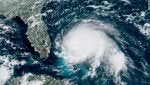
As I write this Hurricane Dorian is reeking havoc in Abaco, one of my favored bonefish habitats. I am deeply concerned for my friends, their families, boats and lodgings there.

dorianbahamas.HPcrop.090119.jpg
 

flyminded

Well-known member
Messages
1,086
Reaction score
44
Location
Lowcountry, SC
Elbow Cay took a beating.

I’ve seen videos from Marsh Harbour of flooding and wind damage. Also seen reports of buildings lost on the south end.
 

brownbass

Well-known member
Messages
1,717
Reaction score
164
Location
Marthasville Mo.
The damage I have seen on-line and the descriptions I have read paint a very dismal image of the island. God help them.

Bill
 

sweetandsalt

Well-known member
Messages
18,477
Reaction score
12,243
Location
South of the Catskills
And today Grand Bahama is getting pummeled. Within the hour satellite images should have the eye directly over a little Cay where I hooked (and lost) a great 10+ bonefish. The tiny camp we styed in may very likely not endure his storm.

190902123317-11-hurricane-dorian-0901-satellite-exlarge-169.jpg
 

karstopo

Well-known member
Messages
3,598
Reaction score
1,978
Location
Brazoria County, SE Texas
Mike's Weather Page... powered by Sparks Energy!

The link has a lot of different “looks” at Dorian.

https://cdn.star.nesdis.noaa.gov/FLOATER/data/AL052019/08/GOES16-AL052019-08-1000x1000.gif

This link shows convection imagery of Dorian stationary, for hours now, right on the north shore of Grand Bahama Island. It’s got to be a living h*ll to be in that kind of intensity of wind, water, and roaring noise for that amount of time.

Hurricane Dorian is caught between two high pressure systems that are effectively holding it in place until it eventually gets lifted north.

Mike's Weather Page - Great map showing current steering of Dorian. High pressure to the west. High pressure to the east. Weakness to the north with approaching front. That is the pull north. Then the natural bend around the Bermuda high (to the east). Little wiggles and wobbles now will be watched the next 24-hour at least to see how close to FL then the same towards GA/SC/NC. I will go live at 8:30pm. www.spaghettimodels.com | Facebook
 

losthwy

Montrose, Co.
Messages
933
Reaction score
421
Location
Montrose, Co.
The devastation in the Northern Bahamas is bad. Thirty foot elevation and 20 foot storm surge. I have been through a Cat 3 which was scary. This is must worst.
Welcome to global warming.
 
I

ikankecil

Guest
I think Abaco is off the list for a while, -even if they get the airport up and running tomorrow, there's inadequate support infrastructure to plan a fishing trip (the market/s in MHH are hosed, no gas stations, etc). I've been going at least once or twice a year for the past 19 years but this put a stop to that. I feel for the people but that's the reality of living in the tropics. When I had a waterfront home in S. FL, it was just a bargain you accepted: live on the water in the tropics, you might get spanked. Abaco did.

Mayaguana anyone?
 

flyminded

Well-known member
Messages
1,086
Reaction score
44
Location
Lowcountry, SC
Yep the logistics of rebuilding are going to be very challenging for an island that wasn’t exactly abundant with resources. Pretty much everything gets shipped in on shallow draft barges. But first the docks need to be rebuilt, the power and water restored and safe secure housing for those still there.
 

pogiepika

Active member
Messages
44
Reaction score
0
Has anyone heard how badly the Marls mangrove system was damaged? I know the Abaco Lodge, right on the edge of the Marls was destroyed.

Interestingly I just heard that one of the guides is going to open a grocery store, gas station etc in South Abaco. I know prior to the hurricane he didn’t have much faith in the Bahamian governments ability to get stuff done and I imagine this is an effort to take the bull by the horns and get something done without the government. I think it will be a long time before Marsh Harbour is sorted out.
 

flyminded

Well-known member
Messages
1,086
Reaction score
44
Location
Lowcountry, SC
From what I’ve seen/heard the south end of the island was relatively unscathed. Utilities and supplies obviously an issue.

I know the school in Cherokee reopened on a restricted hours basis to try and establish some normality for the children still there. Also the grocery/convenience store has recently reopened on restricted hours.

A number of the residents of Cherokee were displaced, safe secure housing of employees for local businesses is now a primary concern.

The big bird poultry farm, about half way between MH and the southern end, suffered damage and apparently lost its entire “orchard” of Avocado trees.
 
Top